The American West faces devastating wildfires annually. Every year, millions of acres are burned. An increasing proportion of large fires have fallen outside the traditional wildfire season, marked from May to September.
In January 2025, Southern California was struck by the Eaton and Palisades wildfires, killing at least 30 people and forcing 200,000 evacuations. These fires burned more than 57,000 acres and destroyed more than 18,000 homes and structures.
Analysis from the UCLA Anderson School of Management estimates total property and capital losses ranging between USD 76 and 131 billion, wage losses of USD 297 million for local businesses and employees, and a 0.48% decline in county-level GDP for 2025.
The Eaton and Palisades fires are the 2nd and 3rd most destructive fires in California’s history, falling behind the Camp Fire in November 2018 that burned 153,336 acres, destroyed almost 19,000 structures, and claimed 85 lives.
Impact of Wildfires on Infrastructure and Economy Since 2000
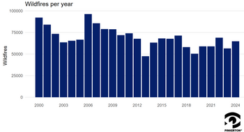
According to data from the National Interagency Fire Center, the annual number of wildfires has decreased slightly since the first decade of the 21st century, but annual numbers of acreage burned remain even, with low years burning around 2.5 million acres and high years burning around 10 million acres.


While the annual number of recorded wildfires has slightly decreased and average burnt acreage per decade has largely held steady over the last 25 years, the costs associated with wildfire suppression have skyrocketed.

In the 21st century, only five years have seen suppression costs total less than USD 1 billion. Since 2011, suppression costs for every year have been in excess of USD 1 billion. The 2020s have witnessed skyrocketing costs, with 2021 through 2024 spending at least USD 3 billion annually.
Wildland-Urban Interface: The Growing Risk of Wildfires Near Homes
Several factors impact the annual fluctuations of burnt acreage and the increase in fire suppression costs, including drought, but a significant factor remains — wildfires proximity to human population centers. Areas of wildland-urban interface (WUI) have increased over the last several decades and contribute to the heightened societal impacts of wildfires.
The 2023 paper, Human and infrastructure exposure to large wildfires in the United States, by Modaresi Rad, A., Abatzoglou, J.T., Kreitler, J. et al., estimated that almost 600,000 people across the United States lived with the perimeters of large fires in the contiguous U.S. during a study period capturing 2000-2019. California accounted for 72% of the cumulative primary population exposure while only accounting for 15% of the burned area.
These researchers also found that California accounts for 11% of the population of the contiguous U.S. living in WUI. When expanding their analyses to populations within a five km buffer around large fire perimeters, they found the impacted population across the contiguous U.S. increased 36-fold. These populations facing secondary exposure can still be subject to evacuations and socio-economic disruptions.
Modaresi Rad et al’s study observed a 125% growth in primary population exposure over two decades, a 185% increase in the western U.S. This was dually impacted by increasing populations in WUI areas as well as fires burning larger areas.
California also led the contiguous U.S. in terms of roads and power lines within the perimeter of large fires, accounting for 18% of roads and 24% of power lines within the perimeter of large fires. They found that exposure of these crucial pieces of human infrastructure increased by 58% during their study period. This growth was attributed to increased large-fire activity rather than changes in the distribution of infrastructure.
Lightning Strikes and Human Sparks: Comparing Wildfire Causes
Most wildfires are caused by human activity, such as downed power lines, improper extinguishing of fires, or arson. Wildfires are also caused by lightning strikes. The annual number of wildfires traced to human causes is much higher than those associated with lightning strikes, but both can wreak immense havoc and burn multitudes of acres and human structures.

Estimates by the National Interagency Fire Center say that up to 20% of all wildfires may be caused by arson. Data from CalFire shows an increase in arson arrests, with 2025 numbers as of April 30.

Wildfire Risk Assessment for Businesses
Pinkerton is an adept partner when it comes to understanding wildfire risk and responding to emergency wildfire situations. Our frontier science risk assessment tool, Risk Pulse, provides highly localized wildfire risk analysis in addition to many other natural disaster hazards that can endanger your people, places, assets, and business continuity. Pinkerton’s wildfire response services have helped with evacuations at medical facilities and business security efforts in the face of California wildfires. When prompt, precisely coordinated action can save lives, Pinkerton’s tradition of excellence can mean a world of difference.
Pinkerton. We Never Sleep.
SOURCES
Li, Z., & Yu, W. (2025, March 19). Economic impact of the Los Angeles wildfires. UCLA Anderson School of Management. https://www.anderson.ucla.edu/about/centers/ucla-anderson-forecast/economic-impact-los-angeles-wildfires
Modaresi Rad, A., Abatzoglou, J.T., Kreitler, J. et al. Human and infrastructure exposure to large wildfires in the United States. Nat Sustain 6, 1343–1351 (2023). https://doi.org/10.1038/s41893-023-01163-z
Statistics. Cal FIRE. https://www.fire.ca.gov/our-impact/statistics
Statistics. National Interagency Fire Center. (n.d.). https://www.nifc.gov/fire-information/statistics


